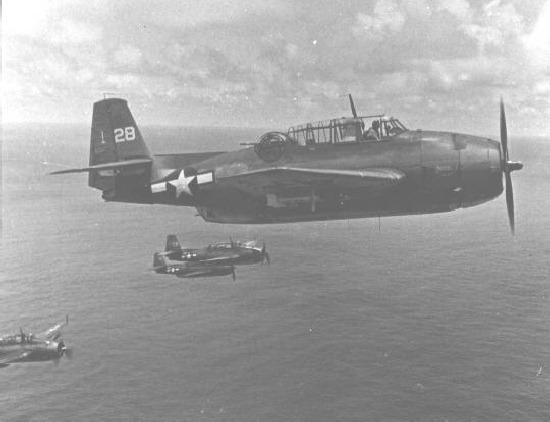
Flight 19 was the designation of five TBM Avenger torpedo bombers that disappeared on December 5, 1945, during a United States Navy-authorized overwater navigation training flight from Naval Air Station Fort Lauderdale, Florida. The assignment was called “Navigation problem No. 1”, a combination of bombing and navigation, which other flights had or were scheduled to undertake that day.
Trouble of an unknown nature plagued the senior aviator designated to observe Flight 19 during this assignment; first with a late arrival requesting to be relieved, then later with complete confusion and irrational fears which further worsened the students’ situation by mistakenly leading them away from land. All 14 airmen on the flight were lost, as well as 13 crew members of a PBM Mariner flying boat, which may have exploded in midair while searching for the flight.
Navy investigators concluded that Flight 19 may have became disoriented and ditched in rough seas when the aircraft ran out of fuel, while the PBM may have been a victim of mechanical failure. Some have questioned the Navy’s version in the years since Flight 19 disappeared. Argosy magazine, Charles Berlitz, and Richard Winer among others used elements first described in American Legion Magazine as well as their own research to publish accounts discussing the Bermuda Triangle.
A fictionalized version of Flight 19 is featured in the 1977 science fiction film Close Encounters of the Third Kind.
On December 5, 1945, Flight 19 undertook a routine exercise to evaluate the men’s navigation and combat operations training in VTB-type aircraft. The flight leader, Lieutenant Charles Carroll Taylor, had about 2,500 flying hours, most in aircraft of this type, while his trainee students had 300 total, and 60 flight hours in the Avenger. Taylor had recently transferred in from NAS Miami where he had also been a VTB instructor. The students had recently completed other training missions in the area where the flight was to take place.
Each aircraft was fully fueled, and in the process of being pre-flighted, when it was discovered they were all missing clocks. Navigation of the route was intended to teach dead reckoning principles, which involved calculating among other things elapsed time. The apparent lack of timekeeping equipment was not a cause for concern as it was assumed each man had his own watch. Takeoff was scheduled for 13:45 local time, but the late arrival of Taylor delayed actual departure until 14:10. Weather at NAS Fort Lauderdale was described as “… favorable, sea state moderate to rough.” On this assignment Taylor was supervising, rather than leading the students in the conduct of the mission unless he believed they had made an error. With a trainee pilot in the role of leader out front, the exercise was called “Naval Air Station, Fort Lauderdale, Florida, navigation problem No. 1,” and it involved the Avengers negotiating a triangular course from and returning to Fort Lauderdale.
After take off they would fly almost due east for 56 miles (90 km) until reaching Hens and Chickens Shoals where bombing practice was planned. The flight was then supposed to continue east another 67 miles (108 km) before turning onto a course of 346 for 73 miles (117 km), in the process over-flying Grand Bahama Island. Finally, Flight 19’s last turn was a course of 241 degrees for 120 miles (193 km), bringing it back to NAS Ft. Lauderdale.
Radio conversations between the pilots were undetectable by base and other aircraft in the area. It is known that the practice bombing operation was completed successfully; around 15:00, an exchange where a pilot requested and was given permission to drop his last bomb indicated they were proceeding on to their first turn. Forty minutes later another flight instructor, Lieutenant Robert Faced Fox in FT-74, forming up with his group of students for the same mission received an unidentified transmission.
A male voice had asked Powers [one of the students] what his compass read, the recorded reply being “I don’t know where we are. We must have got lost after that last turn.” Fox then transmitted; “This is FT-74, plane or boat calling ‘Powers’ please identify yourself so someone can help you.” The response after a few moments was a request from the others in the flight for suggestions. FT-74 tried again and a man identified as FT-28 (Taylor) came on. “FT-28, this is FT-74, what is your trouble?” “Both of my compasses are out”, Taylor replied, “and I am trying to find Fort Lauderdale, Florida. I am over land but it’s broken. I am sure I’m in the Keys but I don’t know how far down and I don’t know how to get to Fort Lauderdale.”
FT-74 informed the NAS that aircraft were lost, then advised Taylor to put the sun on his port wing and fly north up the coast to Fort Lauderdale. Base operations then asked if the flight leader’s aircraft was equipped with a standard YG (IFF transmitter), which could be used to triangulate the flight’s position, but the message was not acknowledged by FT-28. (Later he would indicate that his transmitter was activated.) Instead, at 16:45, FT-28 radioed: “We are heading 030 degrees for 45 minutes, then we will fly north to make sure we are not over the Gulf of Mexico.” During this time no bearings could be made on the flight, and IFF could not be picked up. Taylor was told to broadcast on 4805 kilocycles. This order was not acknowledged so he was asked to switch to 3,000 kilocycles, the search and rescue frequency. Taylor replied – “I cannot switch frequencies. I must keep my planes intact.”
At 16:56, Taylor was sent another request to turn on his transmitter for YG if he had one, with no acknowledgment. A few minutes later he was heard calling to his flight “Change course to 090 degrees (due east) for 10 minutes.” At about the same time, two others in the flight were heard to say “Dammit, if we could just fly west we would get home; head west, dammit.” Later this difference of opinion would lead to questions about why the students didn’t simply head west on their own. It has been explained that this can be attributed to military discipline.
As the weather worsened, radio contact became intermittent, and it was believed that the five aircraft were actually by that time more than 200 miles (322 km) out to sea east of the Florida peninsula. Taylor radioed “We’ll fly 270 degrees west until landfall or running out of gas” and requested a weather check at 17:24. By 17:50 several land based radio stations had triangulated Flight 19’s position as being within an electronic 100 miles (161 km) radius of 29°N 79°W? / ?29°N 79°W? / 29; -79; Flight 19 was north of the Bahamas and well off the coast of central Florida, but nobody thought to transmit this information on an open, repetitive basis.
At 18:04 Taylor radioed to his flight “Holding 270, we didn’t fly far enough east, we may as well just turn around and fly east again”. By that time, the weather had deteriorated even more and the sun had since set. Around 18:20, Taylor’s last message was received. He was heard saying “All planes close up tight … we’ll have to ditch unless landfall … when the first plane drops below 10 gallons, we all go down together.” At the same time, in the same area, SS Empire Viscount, a British-flagged tanker, radioed that she was in heavy seas and high winds northeast of the Bahamas, where Flight 19 was about to ditch.
Earlier, as it became obvious the flight was indeed lost, several air bases, aircraft, and merchant ships were alerted. A PBY Catalina left after 18:00 to search for Flight 19 and guide them back if they could be located. After dark, two PBM Mariner seaplanes originally scheduled for their own training flights were diverted to perform square pattern searches in the area west of 29°N 79°W? / ?29°N 79°W? / 29; -79. PBM-5 BuNo 59225 took off at 19:27 from Banana River Naval Air Station (now Patrick Air Force Base), called in a routine radio message at 19:30 and was never heard from again.
At 19:50 the tanker SS Gaines Mills reported seeing a mid-air explosion, then flames leaping 100 feet (30 m) high and burning on the sea for 10 minutes. The position was 28°35’N 80°15’W? / ?28.59°N 80.25°W? / 28.59; -80.25. Captain Shonna Stanley, reported searching for survivors through a pool of oil, but found none. The escort carrier USS Solomons also reported losing radar contact with an aircraft in the same position and time.
A 500-page Navy board of investigation report published a few months later made several observations.
- Taylor had mistakenly believed that the small islands he passed over were the Florida Keys, so his flight was over the Gulf of Mexico and heading northeast would take them to Florida. It was determined that Taylor had passed over the Bahamas as scheduled, and he did in fact lead his flight to the northeast over the Atlantic. The report noted that some subordinate officers did likely know their approximate position as indicated by radio transmissions stating that flying west would result in reaching the mainland.
- Taylor, although an excellent combat pilot and officer with the Navy, had a tendency to “fly by the seat of his pants”, getting lost several times in the process. It was twice during such times that he had to ditch his plane in the Pacific and be rescued.
- Blame for the loss of Flight 19 was placed on Taylor.
- The loss of PBM-5 BuNo 59225 was attributed to a mid-air explosion.
This report was subsequently amended “cause unknown” by the Navy after Taylor’s mother contended that the Navy was unfairly blaming her son for the loss of five aircraft and 14 men, when the Navy had neither the bodies nor the airplanes as evidence.
Had Flight 19 actually been where Taylor believed it to be, landfall with the Florida coastline would have been reached in a matter of 10 to 20 minutes or less, depending on how far down they were. However, a later reconstruction of the incident showed that the islands visible to Taylor were probably the Bahamas, well northeast of the Keys, and that Flight 19 was exactly where it should have been. The board of investigation found that because of his belief that he was on a base course toward Florida, Taylor actually guided the flight further northeast and out to sea. Further, it was general knowledge at NAS Fort Lauderdale that if a pilot ever became lost in the area to fly a heading of 270 degrees west (or in evening hours toward the sunset if the compass had failed). By the time the flight actually turned west, they were likely so far out to sea they had already passed their aircraft’s fuel endurance. This factor combined with bad weather, and the ditching characteristics of the Avenger, meant that there was little hope of rescue, even if they had managed to stay afloat.
It is possible that Taylor overshot Castaway Cay and instead reached another land mass in southern Abaco Island. He then proceeded northwest as planned. He fully expected to find the Grand Bahama Island laying in front of him as planned. Instead he eventually saw a land mass to his right side, the northern part of Abaco Island. Believing that this landmass to his right was the Grant Bahama Island and his compass was malfunctioning, he set a course to what he thought was southwest to head straight back to Fort Lauderdale. However in reality this changed his course further northwest, toward open ocean.
To further add to his confusion he encountered a series of islands north of Abaco Island, which looks very similar to the Key West Islands. Eventually to Taylor’s horror he was still in the middle of the ocean at where Fort Lauderdale was supposed to be. The control tower then suggested that Taylor’s team should just keep heading west, and they will for sure reach the massive landmass of Florida eventually. Instead of following his compass, Taylor headed for what he thought was west, but in reality was northwest, almost parallel to Florida.
After trying that for a while and no land in sight, Taylor decided that it was impossible for them to fly so far west and not reach Florida. He believed that he might have been near the Key West Islands. What followed was a series of serious confusions between Taylor, his team and the control tower. Taylor was not sure whatever he was near Bahama or Key West, and he was not sure which direction was which due to compass malfunction. The control tower informed Taylor that he couldn’t be in Key West since the wind that day didn’t blow that way. Some of his teammates believed that their compass was working. Taylor then set a course northeast according to their compass, which should take them to Florida if they were in Key West. When that failed Taylor set a course west according to their compass, which should take them to Florida if they were in Bahama. If Taylor stayed this course he would have reached land before running out of fuel. However at some point Taylor decided that he had tried going west enough. He then once again set a course northeast, thinking they were near Key West after all. Finally his flight run out of fuel and they crashed into the ocean somewhere north of Abaco Island and east of Florida.
In 1986, the wreckage of an Avenger was found off the Florida coast during the search for the wreckage of the Space Shuttle Challenger. Aviation archaeologist Jon Myhre raised this wreck from the ocean floor in 1990. He was convinced it was one of the missing planes, but positive identification could not be made. In 1991, the wreckage of five Avengers was discovered off the coast of Florida, but engine serial numbers revealed they were not Flight 19. They had crashed on five different days “all within a mile and a half [~2.4 km] of each other.”
Records showed training accidents between 1942 and 1946 accounted for the loss of 94 aviation personnel from NAS Fort Lauderdale (including Flight 19.) In 1992, another expedition located scattered debris on the ocean floor, but nothing could be identified. In the last decade, searchers have been expanding their area to include farther east, into the Atlantic Ocean. It has been determined through Navy records that the various discovered aircraft, including the group of five, were declared either unfit for maintenance/repair or obsolete, and simply disposed of at sea.
An article in the June 1973 edition of Naval Aviation News describes the baseline Flight 19 disappearance story:
Five Avengers are airborne at 1400 on a bright sunny day. The mission is a routine two-hour patrol from Fort Lauderdale, Fla. due east for 150 miles, north for 40 miles and then return to base. All five pilots are highly experienced aviators and all of the aircraft have been carefully checked prior to takeoff. The weather over the route is reported to be excellent, a typical sunny Florida day. The flight proceeds.
At 1545 Fort Lauderdale tower receives a call from the flight but, instead of requesting landing instructions, the flight leader sounds confused and worried. “Cannot see land,” he blurts. “We seem to be off course.” “What is your position?” the tower asks.There are a few moments of silence. The tower personnel squint into the sunlight of the clear Florida afternoon. No sign of the flight.
“We cannot be sure where we are,” the flight leader announces. “Repeat: Cannot see land.”Contact is lost with the flight for about 10 minutes and then it is resumed. But it is not the voice of the flight leader. Instead, voices of the crews are heard, sounding confused and disoriented, “more like a bunch of boy scouts lost in the woods than experienced airmen flying in clear weather.” “We can’t find west. Everything is wrong. We can’t be sure of any direction. Everything looks strange, even the ocean.” Another delay and then the tower operator learns to his surprise that the leader has handed over his command to another pilot for no apparent reason.
Twenty minutes later, the new leader calls the tower, his voice trembling and bordering on hysteria. “We can’t tell where we are … everything is … can’t make out anything. We think we may be about 225 miles northeast of base …” For a few moments the pilot rambles incoherently before uttering the last words ever heard from Flight 19: “It looks like we are entering white water … We’re completely lost.”
Within minutes a Mariner flying boat, carrying rescue equipment, is on its way to Flight 19’s last estimated position. Ten minutes after takeoff, the PBM checks in with the tower … and is never heard from again. Coast Guard and Navy ships and aircraft comb the area for the six aircraft. They find a calm sea, clear skies, middling winds of up to 40 miles per hour and nothing else. For five days almost 250,000 square miles of the Atlantic Ocean and Gulf are searched. Yet, not a flare is seen, not an oil slick, life raft or telltale piece of wreckage is ever found.
Finally, after an extensive Navy Board of Inquiry investigation is completed, the riddle remains intact. The Board’s report is summed up in one terse statement: “We are not able to even make a good guess as to what happened.”
This version, and its offshoots can be traced to an April 1962 issue of American Legion Magazine, in which author Allan W. Eckert first wrote the “popular” story about Flight 19’s disappearance. Among its assertions, that Taylor had been heard saying “We are entering white water, nothing seems right. We don’t know where we are, the water is green, no white”. It was also said that the Navy board of inquiry stated the planes “flew off to Mars”. Eckert’s article, “The Lost Patrol”, was the first to connect the supernatural with Flight 19, but it would take another author, Vincent Gaddis, writing for Argosy Magazine to put Flight 19 together with other mysterious disappearances and coin a new catchy name in “The Deadly Bermuda Triangle” for a 1964 issue.
He would build on that article with a more detailed book (Invisible Horizons) the next year. Others later followed with their own works: John Wallace Spencer (Limbo of the Lost, 1969); Charles Berlitz (The Bermuda Triangle, 1974); Richard Winer (The Devil’s Triangle, 1974), and many others, all keeping to some of the same supernatural elements outlined by Eckert. Berlitz, grandson of a distinguished linguist and author of various additional books on anomalous phenomena, attributed the loss of Flight 19 to unexplained forces, despite lack of evidence supporting his claim.
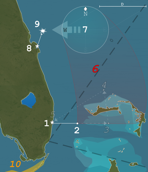
Map of Flight 19’s flight plan and final position on December 5, 1945. D. 100 miles/160 km 0. The Bermuda Triangle 1. Take off from NAS Fort Lauderdale 14:10. 2. Practice bombing at Hens and chickens shoals until around 15:00. 3. First turn, new heading 346° for 73 miles (117 km). 4. Second turn, new heading 241° for 120 miles (193 km). 5. Expected arrival at NAS Fort Lauderdale 6. 15:00–17:50 exact position unknown. 7. 1750 radio triangulation narrows flight’s position to within 100 miles (161 km) of 29°N 79°W? / ?29°N 79°W? / 29; -79 and their last reported course, 270°. 8. PBM-5 (BuNo 59225) takes off from NAS Banana River 19:27. 9. 19:50 PBM-5 (BuNo 59225) explodes near 28°N 80°W? / ?28°N 80°W? / 28; -80. 10. The Florida Keys, where Taylor thought he was
[ Source ]
Leave a comment
You must be logged in to post a comment.